
Drone Photography for Cape Town Properties – Is It Worth It?
As Cape Town’s property market becomes increasingly visual, many sellers, estate agents, and developers are exploring drone photography to gain an edge. Aerial imagery provides a broader context, showcases scale, and creates a striking first impression—especially for premium homes, scenic locations, or large estates.
But is drone photography worth the additional cost? This guide explores the benefits, practical use cases, and considerations for using drone photography in Cape Town property listings.
What Drone Photography Offers
Aerial imagery provides more than just a unique angle. When executed professionally, drone photos contribute significantly to how a listing is perceived online.
Key Advantages:
- Location context: Show the property’s proximity to beaches, parks, or city landmarks
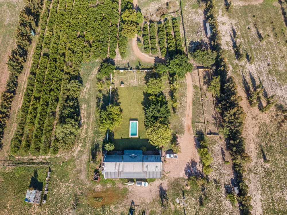
- Visual scale: Highlight large stands, multi-storey buildings, or spacious outdoor areas
- Architectural lines: Capture symmetry and structure from overhead
- Marketing impact: Make listings stand out across portals and social platforms
For homes situated in areas like Clifton, Constantia, Camps Bay, or Bishopscourt, drone shots often reveal value that ground-level photography cannot.
When to Consider Drone Photography
Not every property requires aerial imagery. However, the following types of listings often benefit significantly:
- Luxury homes with views
Elevated perspectives can showcase mountain or ocean views more effectively - Large or complex sites
Properties with multiple structures, gardens, pools, or outbuildings gain clarity from above - New developments or plots
Aerial photos help illustrate layout, boundaries, and location in relation to surroundings - Guesthouses and Airbnbs
Tourism-focused properties near beaches, vineyards, or reserves often attract more interest with dramatic visuals
Professional Execution Matters
Using a licensed and insured drone operator is essential. In South Africa, drone photography is regulated by the South African Civil Aviation Authority (SACAA). Compliance ensures that aerial work is safe, legal, and does not violate privacy laws or no-fly zones.
Additionally, experienced photographers know how to frame compositions from the air, adjust for sun angle, and avoid distortion, resulting in clean, market-ready images that complement the interior and exterior ground-level photography.
What to Expect from the Process
A standard drone session typically takes 30–45 minutes and can be included as part of a broader property shoot. Key deliverables usually include:
- 5–10 professionally edited aerial images
- Resolution suitable for both print and online use
- Optional wide-angle panoramas or vertical views
- Drone footage (if video is part of the package)
Shoot timing is weather-dependent. Clear skies and low wind conditions are ideal for safe and stable flight.
Return on Investment
While drone photography adds to the base cost of a shoot, its impact can be substantial, especially for high-value properties. In many cases, listings with aerial imagery attract more views, generate more interest, and lead to quicker or higher-value offers.
For developers, Airbnb hosts, or tourism property owners, drone imagery also provides versatile marketing assets that can be reused across channels.
Conclusion
Drone property photography is not a necessity for every listing, but when applied strategically, it adds depth, context, and visual impact that standard images alone cannot achieve. For Cape Town properties with scenic views, complex layouts, or strong location advantages, aerial imagery is often worth the investment.
Interested in adding drone photography to your next Cape Town property listing?
Book a Property Shoot with Aerial Add-On
Get in touch via the Contact Page for pricing and availability